|
|
| |
 |
the history of Wieringen
the Roman era
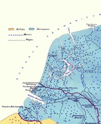
The castellum FlevumBecause of the boggy mess North-Holland was at the time, the Romans were not too keen to add this area to their empire. They built along and north of the borderriver Rhine a series of fortresses of which Castellum Flevum was the largest and best known of the northwest borderarea. Until recently not much was known of Castellum Flevum and for centuries scholars could only guess where it had been. All kinds of option were put forward, from Groningen to Castricum, although most scholars thought, because of its name it had to be near the river Vlie, in those days the only connection between the small lake Flevo and the sea. The legendary Grebbe was also a candidate location for the Castellum, with possible alternative Hippolytushoef. This theory was so popular in the early years of the 20th century that mapmakers drew it on historical maps (see above), even though there was hardly any evidence to support this theory.The Castellum Flevum is especially known because the Romans had to deal with a large Frisian uprising against the heavy taxation in the year 28 A.D. When the Romans increased the taxes, which the local people paid in hides, the Frisians revolted. Tacit writes about this in great detail in the fourth part of his Annales. He describes a large battle near the fortress. The Romans could nearly beat off the attack, but had to abandon the fortress. After this failure the Romans permanently withdrew and made the Rhine the border of the Roman Empire. In the 1990s the riddle of Flevum was finally solved. While building the Velsertunnel remnants were found of a Roman fort. Archeological escavations soon unearthed the remains of a terrible massacre: arrowheads, stone projectiles from Balistas, human bones and remains of swords and daggers came to light. There was no doubt anymore: this had to be the famous Castellum Flevum. Findings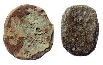 The influence of the proximity of the civilised Romans stretched out over the entire borderarea. This is evident because almost settlement from the period 0-400 that is investigated has some Roman coins and jewellery among the findings. Most likely they ended up in the village by trade. The largest amount of Roman artefacts was found in the 18th century on the island Texel. Here coins, bronze kettles, weapons, tools and household goods, all from the 1st century, were found. The influence of the proximity of the civilised Romans stretched out over the entire borderarea. This is evident because almost settlement from the period 0-400 that is investigated has some Roman coins and jewellery among the findings. Most likely they ended up in the village by trade. The largest amount of Roman artefacts was found in the 18th century on the island Texel. Here coins, bronze kettles, weapons, tools and household goods, all from the 1st century, were found. The local population most likely supplied produce like cereals to the Romans, partly as tribute or tax, partly as trading goods. In any case, there are hardly any indigenous artefacts from this period found. Paludanus' roadsIn Hoorn in the 17th century famous doctor Rutger Paludanus lived. Apart from being a well-respected physician he pioneered the field of local archaeology and history. Even though most of his conclusions are now considered to be superseded, he was the first to describe medieval (and even older) findings in the northern part of Noord-Holland. He found a medieval cemetary on the shallow grounds between Wieringen and the Wieringerwaard and rightly concluded that this part of the sea must have been land in the past. He also was the first to describe a strange phenomenon that has become known as Paludanus' roads. In the Wieringerwaard, recently reclaimed in the early 17th century, strange hardened structures were found at a depth of 1 to 3 feet below ground level. These structures continued beyond the dikes and could be seen at low tide as long straight lines. He thought that they could not have been dikes and after long deliberation he decides they have to be roads. Roads older than the cemetary he had already found, therefore undoubtedly a Roman road.Nowadays historians think these are the remains of dikes after all, especially since aerial photos showed large amounts of parallel lines like Paludanus' roads in most polders and reclamations in northern Noord-Holland. A silent remainder of the struggle against rising water and violent storms that was slowly lost in the 11th through 14th century. The population had to withdraw, leaving behind a pattern of failed dams. The water risesAt the end of the third century the conditions in Noord-Holland get harder (again). The waterlevel rises further and further and it has been suggested that the Frisians leave their homes and settle within the borders of the Roman empire. By doing so they lay the foundations for the great Frisian expansian that would follow the collapse of the Roman Empire, at the end of which the Frisians control the entire coastal region between Belgium and Northern Germany.It is likely that an isolated population of proto-Frisians (or whatever you would like to call them) remains on Wieringen during all these changes, but any contact with Romans or other Frisian settlements will have been very scarce.
|