the history of Wieringen
the middle ages
1. (West-)Friesland
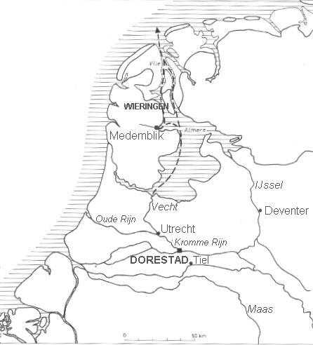
<-- the Low Countries in the Carolingian era (800 AD)
At the end of the 8th century most of Europe was united in the Frankish / Carolingian empire of Charlemagne. In these days the whole coastal area between Zwin (near Sluis in Zeeuws-Vlaanderen) and Weser (Bremen) was known as Frisia or Friesland. It was no well-governed kingdom, more a region where the inhabitants shared a common culture and language. Frisia was at its peak in the 7th and 8th century. The Francian-Merovingian empire defeats the legendary Frisian king Redbad (Radboud) for the first time in 689. Redbad keeps resisting until his death in 719, but the real power is by then in Francian hands. In 734, after Charles Martel finally defeated the Frisians, Frisia became a part of the Francian empire. The Franks partitioned the area into 3 parts: Eastern Friesland between the rivers Lauwers and Weser, Middle Friesland between Vlie and Lauwers and West-Friesland - everything west of the Vlie (the sea arm that was of essential importance for important trading places like Dorestad)
Around 850 most of West-Friesland (present-day Noord-Holland) was moorland. The coastal line was completely different from the one we have now, as can be seen at the map. Wieringen was of major strategic importance, because it was one of only a few firm and higher places on the route to Dorestad.
So Noord-Holland was a part of Frisia, the land of the Frisians. Wieringen was almost in the middle of Frisia. Because of the soggy grounds only a few people lived in Noord-Holland. The only settlements were in the coastal area behind the dunes (Egmond and surroundings), at Medemblik, the oldest city in the area and on Texel and Wieringen. In total no more than 3000 people of whom 25% lived in the region Wieringen. Both Texel and Wieringen were much bigger than nowadays and contained large areas of lower lands that have become part of the Waddenzee later. It must have been possible to walk from Texel to Wieringen in those days. Medemblik on the other hand was virtually unreachable over land from Wieringen.
From this viewpoint it's not hard to imagine that Vikings who wanted to start a colony in Frisia chose to make Wieringen their bridgehead. More about this on a separate page.
Starting in the early 10th century the population of Noord-Holland increases. Large areas of moorland are drained and settlements emerge in formerly inhabitable land. However, the drainage causes the soil to set. During the later Middle Ages most of northern Noord-Holland disappears under water. Where we have the IJsselmeer today, first a small lake emerges, the lake Flevo or Almere, which later grows to become a inland sea, the Zuiderzee.
Wieringen, the old hill in the moorlands, loses much of its territory to the water and changes into an island. This changing geography also changes the strategic importance of Wieringen. For many centuries Wieringen will be an insignificant remote corner and after some time there is not much left to remind of its earlier grandeur.
From Friesland to Holland
As mentioned above West Friesland used to comprise the entire coastal area from Noord-Holland to Zeeland. In the course of centuries the counts of Holland took more and more of this teritory and in the twelfth century West-Friesland is stripped to the 3 remaining independent "gouwen" (something like counties or provinces) Westflinge, Texla and Wiron, all bordering the Vlie. Westflinge is the area between Medemblik, Enkhuizen and Hoorn, present day West-Friesland in other words.
All 12th and 13th century the counts of Holland try desperately to add West-Friesland to Holland. Only when they are weakened by the floods that ravage West-Friesland in the 1280s count Floris V manages to subdue the West-Frisians, and Wieringen.
The count of Holland grands cityrights to Wieringen in 1432. Wieringen was no city in the strict sense of the word, but it meant that fairs etc. could be organised. The famous wooden board that hangs in the Hippolytuschurch, claiming the church was built by count Dirk the 1st of Holland in 866, desecrated by the heathen Norsemen, reinstalled in 986 by Dirk the 2nd (N.B. he was Dirk the 1st his son!) is without any doubt an invention, made to give more creedence to the Dutch claims on Wieringen.. |
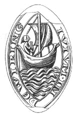
14th century seal of Wieringen |

 Wieringen as a part of the Francian empire Wieringen as a part of the Francian empire
Back to the top of this page
start / Dutch | history | legends | old photos | villages | anthem | links | search
|